ENGLISH

13卷/2期

13卷/2期

華藝線上圖書館

Pages:

75-84

論文名稱

以真實影像自動化敷貼三維建物模型表面之研究

Title

Automated Texture Mapping on 3D Building Model Using Photogrammetric Images

作者

王聖鐸,曾義星, 傅秉綱

Author

Sendo Wang, Yi-Hsing Tseng,Ping-Kang Fu

中文摘要

以三維建物模型取代傳統二維圖籍表達建物的空間資訊,可完整且直覺地呈現建物的外貌,其呈現 方式由僅具建物主體概念的抽象模式,可依不同的需求增加如:陽台、窗台、遮陽罩等細節模型,並於 模型各表面敷貼虛擬材質影像,甚至進一步敷貼實地拍攝之像片,成為擬真式的複雜模型。在模型表面 敷貼真實拍攝的影像能予人如臨現場之真實感,然而傳統的整面敷貼方式需要大量人工量測角點並建立 對應關係,以致模型製作成本高昂。本研究採用浮測模型法重建三維建物之幾何模型,藉由分析建物模 型、拍攝像片、及材質影像之間的幾何關係,逐像元建立材質影像至航測或近景像片之對應關係,並考 慮拍攝距離、拍攝角度、像片品質等成像因素設計一組像片選取指標,以程式自動化選出最適合的來源 影像,藉由投影與重新取樣製成最合理的材質影像,最後以虛擬實境語言(Virtual Reality Modeling Language, VRML)展現三維建物之擬真模型。為驗證其可行性,本研究依據所提方法撰寫一套電腦程式,並選定成 大校園中的兩棟建物為測試對象,實地環繞建物拍攝一系列像片。所使用之數位單眼像機(DSLR)已預 作率定,故像片內方位及透鏡畸變差可據以改正,像片之外方位則是以模型框線為控制線加以求定。故 程式可自動選取最適來源影像,逐像元製作材質影像,最後敷貼至三維建物模型表面,以虛擬實境語言 展現成果。兩棟測試模型之敷貼成果都獲得令人滿意的視覺效果,證實本文所提自動化方法之可行。

Abstract

Photo-realistic texture mapping of 3D object is one of the major subjects in the study of landscape or city modeling. This paper presents an automated method to map realistic texture onto the facades of 3D building models from multiple overlapped images. This method works on condition that the geometric representation of buildings and the image orientation are known. Images used for texture mapping are mainly obtained from close-range photogrammetry. Rigorous mapping function is developed and implemented with the consideration of selecting the most appropriate images to obtain the best mapping texture. Two examples of building structures are demonstrated. The results will be expressed in Virtual Reality Modeling Language (VRML) so that they can be shown with VRML-compatible visualization software.

關鍵字

三維建物模型、材質敷貼、透視投影轉換、近景攝影測量、虛擬實境

Keywords

3D Building Model, Texture Mapping, Perspective Transform, Close-range Photogrammetry, Virtual Reality.

附件檔名

華芸線上圖書館

N / A

備註說明

200806-2-1-75-84

Pages:

85-100

論文名稱

應用空載光達資料推測林木樹高與葉面積指數

Title

Estimating Tree Heights and Leaf Area Index Using Airborne LiDAR Data

作者

彭炳勳,陳朝圳

Author

Bing-Syun Peng,Chaur-Tzuhn Chen

中文摘要

空載雷射掃瞄系統(又稱光達系統)為近年新發展的遙測技術,林業研究上,光達系統已被證實適用 於林木資源、生物量、冠層立體空間繪製,並且能誘導出單木層級的資料,包括單株立木位置及樹高 等。本研究以阿里山地區立木基礎資訊以及溪頭與阿里山地區之葉面積指數資料,探討空載光達在單 株立木高、林分高與葉面積指數之測量正確性與建立推估模式。結果顯示,研究區域63.21%之立木樹 高相對誤差在20%以內,32.72%的立木樹高誤差絕對值在2m 以內,平均林分高推估以樹冠高度模型為 3m 時,以15m×15m 的林分面積,能獲取最佳之相關性(R2=0.979);當點雲密度介於2-4ptsm-2,由光達計 算葉面積指數時,以15m×15m(R2=0.993)為最高,顯示空載光達影像能有效用於葉面積指數之推估,為 台灣林業研究提供一項新的遙測資訊。

Abstract

Airborne light detection and ranging (LiDAR) is an active remote sensing technique, which sends pulses of laser light toward the ground and detects the return times of back-scattered energy in order to determine ranges of the surface. The suitability of LiDAR in forestry is demonstrated by application such as assessment of timber resources and biomass, quantification of 3D canopy structures, as well as derivation of single trees properties like individual tree positions and tree height. In this study, we used the single tree height data was investigated in the Alishan area and LAI data was investigated in the Chitou and Alishan area, and use airborne LiDAR data to measured mean tree height, analyze the relationship between LAI and Laser Penetration Index (LPI) suitable raster cell size and estimation model. The results of the study indicated that the laser single tree height overestimates the ground truth tree height, especially in compression tree. The laser mean height is computed as the arithmetic mean of the largest laser values within grid size of 15m, and the results was R2 = 0.993. The results was R2 = 0.979 when the LiDAR raster grid size was 15× 15 m 2. Therefore, LiDAR data is useful to estimate the LAI. The estimate map of LAI was obtained according to the results of regression analysis, and it can be found that the LiDAR point cloud of three-dimensional structure made the LAI values between forested region and non-forested region had significant differences. It shows that the LiDAR data have better detection ability for the forest canopy. It provides a new remote sensing technique for forestry investigation in Taiwan.

關鍵字

空載光達系統、雷射點雲穿透率、林分結構、葉面積指數

Keywords

Airborne Laser Scanning System, Laser Penetration Index, Stand Structure, Leaf Area Index.

附件檔名

華芸線上圖書館

N / A

備註說明

200806-2-1-85-100

Pages:

101-116

論文名稱

整合房屋、道路及地型模型之航空影像真實正射校正

Title

True Ortho-rectification for Aerial Photos by the Integration of Building, Road, and Terrain Models

作者

李訢卉,陳良健

Author

Shin-Hui Li, Liang-Chien Chen

中文摘要

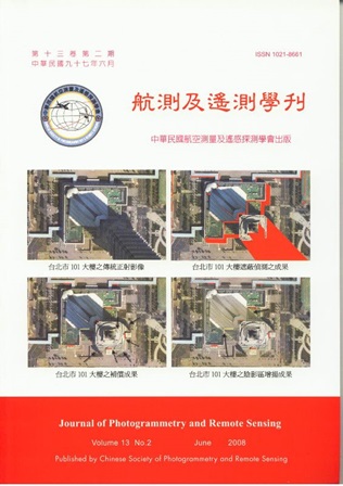
遙測影像幾何校正是資料整合應用前的必要工作。傳統正射改正程序僅處理傾斜移位以及地形起 伏所產生的高差移位。對於高空間解析度影像,含有更細微的地表資訊,地表物高程在影像會產生高 差移位及遮蔽現象。在都市區影像中,高樓和多層道路系統於正射影像中仍有嚴重的幾何變形。真實 正射校正考量地表物,依序改正高差位移和遮蔽,使真實正射影像呈現目標物的正確位置。本研究之 目標物為人工建物 (房屋及道路),故研究中整合房屋、道路和地形模型產生真實正射影像。研究中所 使用的資料包括:三維房屋模型、三維道路模型和數值地形模型以描述物空間地表不同區塊的高低起 伏,研究中使用多視角的高解析空照影像。其中研究主要程序有:(1)視線分析,(2)遮蔽偵測,(3)遮蔽 區補償,及(4)陰影區增揚。研究中使用UltraCam-D 數位空照影像進行校正。實驗成果顯示本方法可有 效的偵測和補償遮蔽區,其成果精度介於1~2 像元。

Abstract

Geometric correction of remote sensing imagery is indispensable for the purpose of data integration and applications. Conventional ortho- recti-fication only considers the correction of tilt displacements and terrain relief displacements. Since high-resolution imagery captures more detailed information, the abrupt changes of object elevation result in the relief displacements and occlusions in images. In urban areas, high-rise buildings and multi-layer road systems of orthoimages cause serious image deformation. True-orthorectification procedures take account of ground objects for the correction of relief displacements and compensation of the hidden areas. Accordingly, the true orthoimages provide the exact position of land objects. This research focuses on the man-made constructions, including buildings and roads. Thus, the generation of true orthoimages is done by the integration of building, road, and terrain models. The test data comprises three dimensional building models, road models and digital terrain models. Multi-view aerial images are employed for the compensation of occlusions. The proposed scheme includes: (1) visibility analysis, (2) hidden detection, (3) hidden compensation, and (4) shadow enhancement. UltraCam-D imagery is used to validate the proposed scheme. The experimental results indicate that the proposed methods may produce quality true-ortho images with the accuracy between 1 and 2 pixels.
關鍵字

真實正射影像、都市、遮蔽區、陰影區增揚

Keywords

True orthoimages, urban, hidden areas, shadow enhancement.

附件檔名

華芸線上圖書館

N / A

備註說明

200806-2-1-101-116

Pages:

117-130

論文名稱

使用空載光達點雲求定數值地表高程模型之小波法

Title

Wavelets-Based Method for Determining DEM by Using Airborne LiDAR Data

作者

鄭邦寧,蔡展榮

Author

Pang-Ning Cheng,Jaan-Rong Tsay

中文摘要

本文應用小波演算法輔助空載光達點雲過濾,使用小波進行內插生成格網化地形初始面,以網格化 資料結構結合Geodesic Dilation法、高程差與其變化率判斷、重新篩選過濾機制,逐步將光達點雲分類為地 面點與非地面點,進一步計算產生地表數值高程模型;過程中可參考光學影像特徵,另外針對橋樑區域 的光達點雲過濾,應用和橋樑走向正交的掃瞄方式搜尋橋樑種子點,配合區域成長法偵測橋樑位置。從 地形簡單的實驗區一至地形複雜且多斷線的實驗區二的點雲分類成果顯示,分類總錯誤率分別為0.5%和 6%,成果頗佳,構想經實際驗證為可行。

Abstract

In this study, the wavelet approach is used for airborne LiDAR data filtering. An initial digital surface model (DSM) is generated by wavelet approach. The method utilizes then geodesic dilation, height difference and second order difference of heights of neighboring grid points, and then re-selects LiDAR points by generating a reference surface to select more reliable terrain points. Finally, those selected terrain points are used to generate the digital elevation model (DEM) in that area. In the process, digital aerial color images and their derived feature figures such as NDVI and GI can be also applied. In addition, a method is proposed to exclude those non-terrain points in a bridge region. A point scanning method is presented to sort the seeds located on the bridge surface. These seeds can be adopted for region growing process. Then all non-terrain points within the bridge area can be found. Both test area I with simpler surface topography and test area II with more complicated surface topography as well as break lines show that the total error of LiDAR point classification is 0.5% and 6%, respectively. They verify the method is applicable for LiDAR point filtering and DEM generation.

關鍵字

空載光達、小波、影像、點雲過濾/分類

Keywords

Airborne LiDAR System, Wavelet, Image, Poiut cloud Filtering /Classification

附件檔名

華芸線上圖書館

N / A

備註說明

200806-2-1-117-130

Pages:

131-146

論文名稱

利用X 頻脈衝式微波雷達偵測近岸碎波位置

Title

Detection of breaking waves using X-band pulse radar in the nearshore region

作者

李明靜, 呂珍謀, 賴泉基,李明憲

Author

Ming-Ching Lee,Jan-Mou Leu, Chan-Ji Lai, Ming-Hsien Lee

中文摘要

本文利用脈衝式都卜勒微波雷達於台北縣貢寮鄉福隆村雙溪河口,進行近岸波浪之觀測。由於同 一測線上,雷達回波會因雷達照射區域內目標散射物之特性不同而有不同的特徵,利用此特性,分析 雷達回波之雷達截面積、都卜勒頻率偏移量、都卜勒頻帶寬度於測線上之不同特徵,便可對近岸波浪 進行觀測。文中利用各測線上觀測所得的結果內插出雷達掃描的範圍,並將各測線上出現不同特徵處 與現場實地的環境相互對照,最後將各測線上產生最大雷達截面積與最大都卜勒頻率偏移之位置依次 連接,便能將近岸海域中波浪發生碎波之位置,直接標定於空間座標系統中。結果顯示,此系統適合 於量測近岸碎波帶之範圍,藉此可進一步了解近岸區海氣交互作用,同時對現場調查人員及儀器設備 而言,較無發生意外之顧慮。

Abstract

This paper is concerning detection and characterization of wave breaking using X-band pulsed Doppler microwave radar nearby the Shuang-Si estuary at Fu-Long village in Taiwan. Along the same measuring line, as the character of subjective scatterers under the radar illuminated area changes, and the features of radar backscatter will be different. The analysis of radar backscatter involved radar cross section, Doppler frequency shift, and Doppler bandwidth from the sea surface is accomplished. Eventually, the maximum radar cross section and Doppler frequency shift on the same measuring line, connect the position on every measuring line respectively. The radar system was shown the capability to delineate the location of breaking wave clearly and that is sufficient for nearshore events of air-sea interactions to achieve a measurement operation. It’s safe and secure for investigators and instruments that they accomplish all detective operation successfully.

關鍵字

都卜勒微波雷達、都卜勒頻率偏移量、雷達截面積、碎波

Keywords

Doppler microwave radar, Doppler frequency shift, Radar cross section, Wave breaking

附件檔名

華芸線上圖書館

N / A

備註說明

200806-2-1-131-146

Pages:

147-158

論文名稱

應用多重尺度區塊成長技術於高解析遙測影像之影像分割

Title

A Multi-Scale Region Growing Segmentation For High Resolution Remotely Sensed Images

作者

張立雨,陳繼藩

Author

L. Y. Chang,C. F. Chen

中文摘要

就各種遙測影像而言,影像分割對於辨識其中之區塊物件是一項重要之前處理程序。而應用區塊 成長技術進行影像分割則是在影像分割中非常廣為使用之方法。然而,應用區塊成長進行影像分割時 所必須設定之成長門檻值則是可否得到良好分割結果的關鍵。不適當之門檻值設定不但造成影像之過 度分割(over-segmentation)或是分割不足(under-segmentation),並且無法針對影像中之特徵產生合理之區域 資訊。為了克服門檻值設定問題,本研究提出以最大邊緣密度變化率為基礎之多重尺區塊成長技術來 進行影像之分割。為了測試所提方法的適用性,在測試過程中分別針對模擬影像以及各種不同感測器 所獲取之高解析遙測影像進行測試。測試結果顯示本研究所提方法可不需直接設定特定門檻值,並且 針對不同影像中之區塊物件得到相對合理之影像分割結果。

Abstract

For remotely sensed images, region growing segmentation is a widely-used technique for object extraction and identification. However, the main drawback of region growing segmentation is the threshold setting for stopping the growth of a region. Improper threshold setting not only causes over-segmentation or under-segmentation, but also cannot create needed object regions for various targets. In order to overcome these drawbacks, a multi-scale region growing segmentation method, based on the maximization of the change of edge density, is proposed. Experiments, including different kinds of high resolution remotely sensed images are used to test the performance of the proposed scheme. The experimental results show that the proposed scheme can both remove the limitation of threshold setting and generate relatively reasonable segmentation output for different types of objects.

關鍵字

影像分割、邊緣密度、高解析遙測影像

Keywords

Image Segmentation, Edge Density, High Resolution Images

附件檔名

華芸線上圖書館

N / A

備註說明

200806-2-1-147-158

更多活動學刊