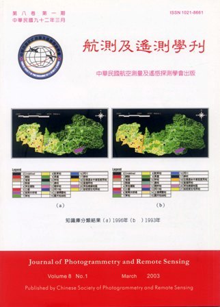
In order to identify the spatial pattern of urban land use change, this research designed a study applying the technique of Experts' Knowledge Base. The result shows: with the aid of GIS spatial database, it is feasible to integrate various infrastructures of data (RS,GIS), and simplified traditional time-consuming and sophisticated process. The use of experts knowledge and experiences, accompanied with the mechanism of logical inference extract from database, we can rapidly and efficient perform urban land use change identification. On the other hand, for probing into the multi-temporal land use change form, the research also build up a model to semi-auto detect the classification output. The processing stage can be divided into two major parts: image classification and land used change detection. This study concludes, using this process can achieve the goal of semi-auto land use change detection, and it's suitable to analyze the urban land use change.